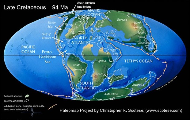
The Cretaceous Period (145- to 65 million years ago) was hot and steamy. There was no ice at the poles. Global temperature is estimated to have been about 18 F warmer than today. Atmospheric carbon dioxide began a 145-million-year decline from about 2,000 ppm to the 380 ppm of today, in part, due to carbon sequestration by formation of coal deposits. Flowering plants appeared.
The North American continent was split by a sea connecting the Gulf of Mexico with the Arctic Ocean. Transgressions and regressions of this sea formed conditions ripe for coal formation similar to those in the Paleozoic Era In Southern Arizona, the lower Cretaceous Bisbee Group, consisting of the basal Glance conglomerate, the Morita formation sandstones and mudstones, the distinctive Mural Limestone (which forms the cliffs just east of Bisbee), and the sandstones and mudstones of the Cintura Formation record the changes in sea level. Upper Cretaceous rocks, the Fort Crittenden Formation lie unconformably (representing erosion or structural change) upon the Bisbee Group. The lower Fort Crittenden is dominated by marginal wetland to deep-water lake deposits, whereas the upper Fort Crittenden is characterized by wetland to deltaic deposits. These rocks contain organic geochemical evidence of wildfires which suggest that seasonal aridity and wildfires were common occurrences.
There are no early Cretaceous rocks recognized in northern Arizona. Thick sequences of upper Cretaceous rocks were deposited on what is now the Colorado Plateau. These represent near-shore marine, coastal, and river-deposited sands, mudstone, and coal. Coal is mined from the Dakota sandstone at Black Mesa in Navajo County, AZ. This is overlain by the Mancos Shale, and several other sedimentary formations.
The Laramide orogeny of late Cretaceous to early Tertiary time (80- to 40 million years ago) built the Rocky Mountains and closed the inland Cretaceous sea. Subduction of oceanic crust under continental rocks along the west coast caused compression and uplift of the continent.
This was the time of emplacement of most of the porphyry copper deposits in the western U.S. Volcanism was extensive, and included the volcano that produced the rocks of the Tucson Mountains.
 Dinosaurs roamed the land, including Arizona’s Sonorasaurus thompsoni, a new species of brachiosaurid dinosaur whose remains were first discovered in the Whetstone mountains by UofA graduate geology student Richard Thompson in 1994. Sonorasaurus is estimated to have been about 50 feet long and 27 feet tall, about one third of the size of other brachiosaurus. It may have been a juvenile or just a small dinosaur species. Sonorasaurus was an herbivore. Tooth gouges on its bones suggest it was killed and eaten by a larger dinosaur. A single blade-like tooth of a huge meat eater called Acrocanthosaurus was found near the bones and suggests that this was the predator that killed Sonorasaurus. You can see an exhibit dedicated to Sonorasaurus at the Arizona-Sonora Desert Museum.
The end of the Cretaceous Period saw another major extinction of life. Dinosaurs, pterosaurs, many marine reptiles, some marine invertebrates, some groups of mammals, and a few plant groups became extinct. The reasons are still controversial. We know that an asteroid impacted near Yucatan, Mexico and formed the Chicxulub crater about 65 million years ago. The impact is said to have vaporized rock into clouds of dust, that cooled temperatures, and created clouds of sulfurous gas, which may have killed plants with acid rain. The impact is also said to have deposited a thin clay layer containing iridium and strained quartz. However, the extinction occurred during an 800,000-year eruption of basalts that form the Deccan Traps in India. Volcanic eruptions can also product dust and sulfur dioxide emissions (and layers of iridium which characterize the K/T boundary). More precise dating shows that the Chicxulub impact occurred 300,000 years before the mass extinction. Evidence suggests that the extinctions occurred over a period of several million years.
Cretaceous Trivia:
The white cliffs of Dover, England are Cretaceous age chalk deposits.
Paul Spur, a rail stop between Bisbee and Douglas exists because Mural limestone was mined for smelter flux.
Hills carved from Cretaceous beds east of Bisbee. View is northward across Mule Gulch. The prominent white band is the upper member of the Mural limestone, forming the top of Mural Hill on the left and showing the dislocation due to the Mexican Canyon fault. Cochise County, Arizona. December 1, 1902. Plate 9-B in U.S. Geological Survey. Professional paper 21. 1904, figure 7 in U.S. Geological Survey Folio 112. 1904.
References:
Dickinson, W.R., et al., 1989, Cretaceous Strata of Southern Arizona, in Geologic Evolution of Arizona, Arizona Geological Society Digest 17.
Finkelstein, D.B, et al., 2005, Wildfires and seasonal aridity recorded in Late Cretaceous strata from south-eastern Arizona, USA, Sedimentology, Volume 52, Issue 3 , Pages587 – 599, International Association of Sedimentologists
Krantz, R.W., 1989, Laramide Structures of Arizona, in Geologic Evolution of Arizona, Arizona Geological Society Digest 17.
Nations, J.D., 1989, Cretaceous History of Northeastern and East-Central Arizona, in Geologic Evolution of Arizona, Arizona Geological Society Digest 17.

