Geology

Critical mineral resources of the United States

The U.S. Geological Survey has just published a new assessment of mineral resources vital to our modern economy: Critical mineral resources of the United States—Economic and environmental geology and prospects for future supply, Professional Paper 1802

Edited by:Klaus J. Schulz , John H. DeYoung Jr. , Robert R. Seal II , and Dwight C. Bradley

You can download the entire book (148 Mb) and/or individual chapters here:

https://pubs.er.usgs.gov/publication/pp1802


The book consists of two introductory chapters and 20 chapters which each discuss the geology, mineralogy, and occurrence of specific mineral commodities. Note that the U.S. is entirely dependent on imports for 20 critical minerals (see page 6 of this publication for a chart:https://minerals.usgs.gov/minerals/pubs/mcs/2017/mcs2017.pdf )

The following map from PP1802 shows where the U.S. gets minerals for which we are at least 50 percent dependent on imports.


The first chapter in PP1802 justifies the need for this report as follows:

The global demand for mineral commodities is at an all time high and is expected to continue to increase, and the development of new technologies and products has led to the use of a greater number of mineral commodities in increasing quantities to the point that, today, essentially all naturally occurring elements have several significant industrial uses. Although most mineral commodities are present in sufficient amounts in the earth to provide adequate supplies for many years to come, their availability can be affected by such factors as social constraints, politics, laws, environmental regulations, land-use restrictions, economics, and infrastructure.

This volume presents updated reviews of 23 mineral commodities and commodity groups viewed as critical to a broad range of existing and emerging technologies, renewable energy, and national security. The commodities or commodity groups included are antimony, barite, beryllium, cobalt, fluorine, gallium, germanium, graphite, hafnium, indium, lithium, manganese, niobium, platinum-group elements, rare-earth elements, rhenium, selenium, tantalum, tellurium, tin, titanium, vanadium, and zirconium. All these commodities have been listed as critical and (or) strategic in one or more of the recent studies based on assessed likelihood of supply interruption and the possible cost of such a disruption to the assessor. For some of the minerals, current production is limited to only one or a few countries. For many, the United States currently has no mine production or any significant identified resources and is largely dependent on imports to meet its needs. As a result, the emphasis in this volume is on the global distribution and availability of each mineral commodity. The environmental issues related to production of each mineral commodity, including current mitigation and remediation approaches to deal with these challenges, are also addressed.

See also:

American non-fuel mineral production 2016

This article notes: The value of all non-fuel minerals produced from U.S. mines was $74.6 billion, a slight increase over production in 2015. “ Domestic raw materials and domestically recycled materials were used to process mineral materials worth $675 billion. These mineral materials were, in turn, consumed by downstream industries with an estimated value of $2.78 trillion in 2016.” Nevada was ranked first with a total mineral production value of $7.65 billion, mainly from gold. Arizona came in second in total production with a value of $5.56 billion and first in U.S. copper production.

Eldred Wilson’s Proterozoic Mazatzal Revolution Arizona

The Arizona Geological Survey has just made available for download papers by Eldred Wilson, a pioneer of Arizona geology.

Eldred Dewey Wilson & the Proterozoic ‘Mazatzal Revolution’

Study area map of Wilson (1937)

In 1937, geologist Eldred Dewey Wilson coined the phrase ‘Mazatzal Revolution’ to describe mountain building along the western edge of the North American craton. While the Mazatzal Revolution occurred in the Proterozoic – more than 1.6 billion years ago – it continues to influence Arizona geology and mineral exploration to this day. Wilson’s 1937 Ph.D. research is now available online for the first time.

In about 1920, twenty-two-year old Eldred Dewey Wilson joined a handful of geologists – N.H. Darton, Carl Lausen and Olaf P. Jenkins, among them – wrestling with the complex geology of the rugged mountains of southern and central Arizona. Wilson was an assistant geologist at the Arizona Bureau of Mines and working on his M.S. thesis, ‘The Mazatzal Quartzite, a new pre-Cambrian formation of central Arizona’ at the University of Arizona. In 1924 Wilson was promoted to geologist at the Bureau, where he remained, with a short leave of absence to begin his doctoral research in 1931-1932 at Harvard University, until his death in 1965.

Wilson set out in 1930 to address, ‘the chief features of pre-Cambrian regional structure within part of central Arizona’, for his Ph.D. dissertation – ‘‘The Pre-Cambrian Mazatzal Revolution in Central Arizona’. His field area included the Mazatzal Mountains, Pine Creek, eastern Tonto Basin or northern Sierra Ancha, Del Rio, and the southern Black Hills areas, all of which contained extensive outcrops of Proterozoic-age rocks. Wilson concluded from his observations of the field relationships of rocks and structures that the ‘principal features of regional structure originated from a great pre-Cambrian crustal disturbance’, which he called the ‘Mazatzal Revolution’.

Wilson’s ‘Mazatzal Revolution’ was an early contribution to deconstructing the processes responsible for the geology of central Arizona. He noted, ‘The subparallel folds, thrust faults, and imbricate, steeply dipping reverse faults clearly resulted from intense north­west-southeastward regional compression. The transverse faults are believed to have been formed, also during the compression, by shearing normal to the trend of the folds.’

Wilson hypothesized, too, that, ‘structural weaknesses inherited from the Mazatzal Revolution may have influenced the localization of many of Arizona’s prevailingly north­eastward-trending veins and the pattern of the Tertiary Basin and Range faulting.’ The orogenic Mazatzal Revolution continues to impact Arizona geology today.

E.D. Wilson ca. 1960s.

Reynolds & Others (2013) on Eldred Dewey Wilson’s contribution to Arizona geology. Wilson published a number of important papers on Arizona geology. According to Reynolds and others (2013), Eldred D. Wilson provided the first geologic map and cogent discussion of the geology and mineral resources of southern Yuma County: “Wilson mapped this hitherto unknown area of southwestern Arizona from 1929-1932. In the process, he discovered a new set of mountains that had been overlooked by previous geologists and explorers. He named this range the Butler Mountains after G. M. Butler, former Director of the Bureau and Dean of the College of Mining and Engineering (Wilson, 1931). Wilson was the first person to describe and map the geology of a large number of mountain ranges in southwestern Arizona. The data from Wilson’s 1933 geologic map were incorporated into the 1969 state geologic map.”

See James T. Forrester and Richard E. Moore’s ‘Memorial to Eldred Dewey Wilson 1898-1967’ for more about the life and times of Dr. Wilson.

Note: AZGS thanks an anonymous patron who arranged at his/her own expense with Harvard University to scan Wilson’s dissertation and secure copyright permission from Dewey Wilson to re-release Dr. Wilson’s work as CR-17-C.

References 
 
Forrester, J.T. and Moore, R.E., 1965 Memorial to Eldred Dewey Wilson 1898-1967. Geological Society of America Bulletin, V. 76, p. 187-191.

Reynolds, S., Spencer, J.E., Richard, S.M., Pearthree, P.A. 2013, The Geological Exploration of Arizona: The Role of State and Federal Surveys and the Geologic Map of Arizona, Arizona Geology Magazine, Winter 2013.

Wilson, E.D., 1922, The Mazatzal Quartzite, a new pre-Cambrian formation of central Arizona. Univ. of Arizona M.S. thesis, 40 p.

Wilson, E.D., 1937, The Pre-Cambrian Mazatzal Revolution in Central Arizona. Ph.D. Dissertation, Harvard University, Cambridge, MA, 335 p.

This post is reblogged from Arizona Geology

American Geosciences Institute’s Critical Issues program

agi

The Arizona Geological Survey’s winter e-magazine features an article about the American Geosciences Institute’s Critical Issues program (www.americangeosciences.org/critical-issues).

The aim of this AGI program is to pioneer a new approach to sharing societally-relevant science with state and local decision makers. “Here in Arizona, we are sharing this with state and local decision-makers to help them wrap their heads around the complex issues involving groundwater, geologic hazards, and sustainable natural resource management.”

The program aims to support connections and communication between the geoscience community and decision makers. Although the program caters to decision makers at all levels, it particularly focuses on state and local decision makers because these stakeholders are commonly underserved by geoscience policy efforts.

The program convenes meetings, such as the AGI Critical Issues Forum, but its main interface is a web-based platform of resources that bring the expertise of the geoscience community to decision makers by offering a curated selection of information products from sources that include state geological surveys, federal and state agencies, and AGI’s member societies.

The Critical Issues program offers the following freely accessible information services:

Research database: Over 4,000 publications primarily from state geological surveys and the U.S. Geological Survey.

Webinars: Free webinars on a variety of topics that bring geoscientists and decision makers together to discuss potential solutions to challenges at the interface of geoscience and society.

Maps & Visualizations: 144 interactive maps and visualizations covering all 50 states and the District of Columbia.

Case studies: A new product that is coming online in Spring 2017. Specific applications of geoscience to societal problems.

Fact Sheets: A new product that is coming online in Spring 2017. Provide more in-depth information on the big issues.

Frequently Asked Questions: 105 questions on topics including: climate, energy, hazards, mineral resources, and water.

Read more at:

http://repository.azgs.az.gov/sites/default/files/dlio/files/nid1709/agi_critical_issues4-final.pdf

This AZGS e-Magazine also includes an article about groundwater use in the United States.


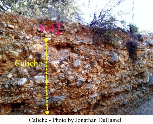
Caliche – natural concrete, can you dig it?

Caliche 3
If you try to dig a hole in your yard in Tucson, chances are that you will soon hit a very hard, almost impenetrable layer.
The term “caliche” is a colloquial word that means different things in different places. In the Sonoran Desert, it means a mixture of gravel, sand, clay and other desert debris cemented by porous calcium carbonate and is  more properly called a calcic horizon. These calcic horizons generally occur two to four feet below the surface and can be inches to many feet thick. Caliche forms only in arid and semi-arid areas. In Tucson, with an average annual rainfall of 10 to 12 inches, caliche forms more than ten inches below the surface. In contrast, in Yuma, which receives about four inches of rain annually, caliche may form at the surface or just a few inches below the surface.
Caiche formation
According to the Arizona-Sonora Desert Museum:
“Thick, strongly-cemented calcic horizons take a long time to form. They start as thin, patchy coats of whitish calcium carbonate on the lower surfaces of pebbles and small stones. In fine-grained parent materials, such as dune sand, that lack coarse materials, calcium carbonate first appears as thin, white, thread-like accumulations where small roots have extracted soil water and caused the calcium carbonate to precipitate. These weakly-developed calcic horizons can form within a few thousand years. Accumulation of more calcium carbonate eventually produces thicker, continuous coatings on pebbles and stones or pronounced whitish nodules in fine-grained parent materials. Eventually, additional accumulation of calcium carbonate fills the soil interstices between pebbles or nodules and the calcic horizon becomes plugged, greatly restricting the downward movement of water. Once this occurs, calcium carbonate may continue to accumulate on the top of the calcic horizon in hard, cemented layers and may literally engulf and obscure overlying soil horizons in the process. It takes many tens to hundreds of thousands of years for such strongly-developed calcic horizons to form.” (Source)
Caliche can form in soil developed from rocks that have little or no calcium carbonate. The calcium carbonate is derived from dust in the atmosphere and from calcium carbonate dissolved in rainwater. Dust that falls on the ground is gradually dissolved as the slightly acidic rainwater penetrates the surface. Calcium carbonate precipitates out of solution as the soils dry and provides the cement to hold the soil particles together to form the concrete-like calcic horizon.
In very arid regions, calcium sulfate (gypsum) and sodium chloride (salt) is formed instead of calcium carbonate. In the Atacama Desert of Chile, caliche also contains sodium nitrate and potassium nitrate. Nitrate, a major ingredient of explosives, was mined and exported to Europe. The importance of this source of nitrate lead to naval battles between Germany and England at the start of WWI. (Source)
In many parts of the world, caliche is used as road pavement or underlayment. It is also used as a source of calcium for manufacture of cement.
The ancient Mayan culture used caliche for building construction.
Caliche layers can be a problem for agriculture and gardening, mainly by preventing drainage. The University of Arizona College of Agriculture has some helpful advice here. Basically they recommend that if you can’t dig through all of the caliche, at least punch some drainage holes in it.

A Guide to the Geology of the Santa Catalina Mountains

Cover santa catalina mtnsThe Arizona Geological Survey (AZGS) has just released a new publication that is available for free download here: http://repository.azgs.az.gov/uri_gin/azgs/dlio/1679
The paper citation is: “Bezy, J.V., 2016, A Guide to the Geology of the Santa Catalina Mountains, Arizona: The Geology and Life Zones of a Madrean Sky Island. Arizona Geological Survey Down-to-Earth # 22, 83 p
The description from AZGS:
This is a non-technical treatment of the geology and ecology of the Santa Catalina Mountains, Tucson, Arizona. Natural landscapes have distinctive personalities. Each is the product of the interplay of geology, climate, vegetation, time, and often, human activities. The landscapes that form the Santa Catalina Mountains of southeastern Arizona give that range a unique personality like no other in the American Southwest. Rising as a great mountain island to over 9000 feet in elevation at their summit, Mount Lemmon, the Santa Catalina Mountains are the greatest expanse of high country within the Sonoran Desert. An unusual dome-like profile  sets it apart from the numerous, steep, sharp-crested mountain ranges in the region. This distinctive profile is a legacy of the range’s remarkable geologic history and the structure of its bedrock. Formed miles deep within Earth’s crust before being exhumed, this ancient structure has guided surface weathering and erosion for millions of years. The result is a mosaic of mountain landscapes of singular beauty and complexity.
This publication contains some 83 spectacular photos and figures.  It gives a very good introduction to the geology and geological processes that formed the range and also describes its life zones.
The rocks in the Santa Catalina Mountains record 1.65 billion years of history. The publication is written for both the general public and geologists.  Take a look and gain an appreciation of that history for when you travel the mountains.

AZ Geological Survey makes 20,000 documents available for free

Unpublished one-of-a-kind Arizona mining documents – once filed away in cabinets and cardboard boxes – are now online, discoverable, and accessible at the Arizona Geological Survey Mining Data website (http://minedata.azgs.az.gov/).

More than 20,000 files, maps, and reports contributed by dozens of exploration geologists and mining firms are now available. The website exposes more than 8,500 geologic and engineering reports; 6,800 maps – geologic maps, mining claim maps, maps with assays, plats, underground maps and cross sections; and 5,500 historic photographs dating from the 1890s to 2000.

“The ability to deliver such a large volume of historical mining maps and documents to the public, free of charge, fills a critical need for bolstering mining efforts in Arizona. It provides an invaluable resource for planning future mineral exploration efforts.” according to Lee Allison, State Geologist and Director of the Arizona Geological Survey.

This new online resource is being premiered in time for the 2016 Society for Mining, Metallurgy & Exploration Annual Conference and Expo in Phoenix from Feb. 21 – 24. The collection includes major exploration holdings from the Arizona Department of Mines and Mineral Resources, Walter E. and Grover Heinrichs, James Sell, A.F. Budge Mining Ltd., Cambior Exploration, among many others.

Since the 1850s, Arizona has been a mecca for prospectors, exploration geologists and mining firms seeking copper, gold, silver, molybdenum, zinc, lead, manganese, tungsten, uranium, and coal, turquoise and semi-precious gems. Collectively, they left a mile-high paper trail of hundreds of thousands of pages, tens of thousands reports, well logs, letters, photographs, and geologic and mine maps.

The documents comprising this online repository were originally provided to the Arizona Mines and Mineral Resources Department by exploration geologists and mining firms.

The Mining Data site includes an applied search tool filtered by key words, mine names, collections, time and place. The geographic search tool provides for a radius search of 1 to 100s of miles from a point of interest for these georeferenced data.


New Release – AZGS field guides to Arizona Geology

The Arizona Geological Survey has just e-published field guides to Arizona geology. The 422-page series of illustrated guides is available for free download at http://repository.azgs.az.gov/uri_gin/azgs/dlio/1646

These guides were originally published as the proceedings of the 100th annual meeting of The Geological Society of America (GSA) was held in Phoenix, Arizona in October 1987. The newly available online guides are organized into separately downloadable sections.

One guide that may be of interest to laymen is “The Archaeological Geology of Paleo.-Indian Sites in Southeastern Arizona” which begins on page 212 of the Southern Arizona section. This paper discusses the late Quaternary geologic history preserved in the sediments in the San Pedro Valley and the Sulphur Springs Valley in southeastern Arizona . “These sediments are host to some of the oldest archaeological remains in North America.” Along the San Pedro River near Tombstone, “The Murray Springs Clovis site is unique in that it contains three distinct activity areas where a band of Clovis hunters killed a mammoth and several bison and occupied a small campsite during two or three brief visits 11,000 years ago. The buried occupation surface is clearly displayed in the arroyo walls as an erosional contact at the base of a distinctive black organic mat that preserved artifacts and extinct animal bones in their original position, and mammoth tracks, just as they were left 11,000 years ago.”

Here are the papers and guides:

NORTHERN ARIZONA

Field-Trip Guide for Marble Canyon and Eastern Grand Canyon

Field Guide to the Lower Grand Canyon, from Peach Springs to Pierce Ferry

Geology of the Lower Grand Canyon and Upper Lake Mead by Boat–An Overview

Geology of the Grand Canyon – A Hike Through Time

Upper Holocene Alluvium of the Southern Colorado Plateau

Late Pleistocene Alluvium and Megafauna Dung Deposits of the Central Colorado Plateau

Late Cenozoic Volcanism in the San Francisco and Mormon Volcanic Fields

A Field Guide to the Jemez Mountains Volcanic Field, New Mexico

Stratigraphy, Correlation, and Tectonic Setting of Late Cretaceous Rocks in the Kaiparowits and Black Mesa Basins

Field Guide to Sedimentary Structures in the Navajo and Entrada Sandstones in Southern Utah and Northern Arizona

CENTRAL ARIZONA

Late Paleozoic Depositional Systems, Sedona-Jerome Area, Central Arizona

Tectonic and Magmatic Contrasts Across a Two-Province Proterozoic Boundary in Central Arizona

Geomorphology and structure of the Colorado Plateau/Basin and Range Transition Zone

SOUTHERN ARIZONA

Land Subsidence and Earth-Fissure Formation in Eastern Phoenix Metropolitan Area, Arizona

Selected Hydrogeologic Problems in Central Arizona

The Archaeological Geology of Paleo-Indian Sites in Southeastern Arizona

Terraces of the Lower Salt River Valley in Relation to the Late Cenozoic History of the Phoenix Basin, Arizona

Late Cenozoic Deposits, Vertebrate Faunas, and Magnetostratigraphy of Southeastern Arizona

Caldera Structures Along the Apache Trail in the Superstition Mountains, Arizona

Field Guide to Lower- and Upper-Plate Rocks of the South Mountains Detachment Zone, Arizona

Structural Geology of the Rincon and Pinaleno Metamorphic Core Complexes, Southeast Arizona

Pinto Valley Copper Deposit

Tectonic Setting and Sedimentological Features of Upper Mesozoic Strata in Southeastern Arizona

Lower Cretaceous Coral-Algal-Rudist Patch Reefs in Southeastern Arizona

WESTERN ARIZONA

Paleoecology and Taphonomy of Recent to Pleistocene Intertidal Deposits, Gulf of California

Volcanic Structures and Alkaline Rocks in the Pinacate volcanic field of Sonora, Mexico

The Mesquite and Picacho Gold Mines: Epithermal Mineralization localized within Tertiary Extensional Deformation

Mesozoic Tectonics of Southeastern California

Field-Trip Guide to Parts of the Harquahala, Granite Wash, Whipple, and Buckskin Mountains,
West-Central Arizona and Southeastern California

Metamorphic Core Complexes, Mesozoic ductile Thrusts, and Cenozoic Detachments: Old Woman Mountains-Chemehuevi Mountains Transect, California and Arizona

Miocene Extension, Volcanism, and Sedimentation in the Eastern Basin and Range Province, Southern Nevada

Crustal Transect: Colorado Plateau-Detachment Terrane-Salton Trough

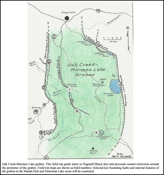
Field Guide – Oak Creek-Mormon Lake Graben Northern Arizona

The Oak Creek-Mormon Lake Graben lies between Flagstaff and Sedona, Arizona. The Arizona Geological Society and geologist Paul A. Lindberg have produced a 13-page field guide to the geology of the area (shown on the map below).

This geologic field trip guide circumnavigates a loop of ~120 miles from Flagstaff to Sedona along Highway 89A and returns to Flagstaff along the Lake Mary Road. The guide contains many illustrations and photographs and may be downloaded from:
http://tinyurl.com/AGS-Spring2015-Fieldtrip

Lindberg introduces us to the local geological setting:

“The Oak Creek-Mormon Lake graben (a rift valley formed by extension of the earth’s crust) has been faulted into the southwestern margin of the Colorado Plateau as basin and range crustal extension has migrated eastward across Western U.S. over time. The graben may be as young as 2-3 million years old, based upon the youthful appearance of numerous V-shaped canyons (Oak Creek, West Fork, Munds, Woods and Rattlesnake Canyons) that cut the minimally eroded original surface of the largely basalt covered core of the graben. That morphology is in sharp contrast to more maturely eroded landforms along the northeast margin of 10 Ma Verde graben near Sedona. Timing of the genesis of the Oak Creek-Mormon Lake graben may be contemporaneous with the main eruptive cycle of San Francisco Peaks north of Flagstaff, Arizona.”

The 12 geologic stops focus on recent faulting and the encroachment of Basin and Range extensional structures on the Colorado Plateau. Each stop is detailed in the text, which is amply illustrated with photographs and colored geologic sketches.

Oak Creek Graben map

Arizona Geological Survey adds Jim Sells data collection to database

Mining collectionsThe Arizona Geological Survey (AZGS) has a new website for mining data. This is a culmination of consolidation of the now defunct Arizona Department of Mines and Mineral Resources (ADMMR) with the AZGS.

Over the past several years, AZGS has performed a comprehensive inventory of the 30 archival collections, creating finding aids for the more than 10,000 folders, 6,000 maps, and 7,000 photographs.

Visit the new Mining Collections site here:                   http://minedata.azgs.az.gov/content/mining-collections

On July 2, 2014, the James Doyle Sell collection, which include more than 800 Arizona mine file records, was added to the Arizona Geological Survey Mine Site. The Sell mining collection comprises over 1,800 folders containing geologic reports and mineral exploration data from around the world, but primarily from Arizona and other states in the Southwest.

James (Jim) Sell was a native Arizonan, born in Casa Grande in 1930; he passed away on 18 Feb. 2011. For 32 years, Jim worked for ASARCO, where he served for some years as Southwest Exploration Manager. During his long career, Jim engaged in 100s of exploration and mining projects. A meticulous fellow, Jim kept records of most of these endeavors and donated his entire collection to the Arizona Dept. of Mines and Minerals Resources (ADMMR). See an article in Arizona Geology Magazine here.

Go to http://repository.azgs.az.gov/uri_gin/azgs/dlio/1439 to see an inventory of material in the collection.